
Overview
Introduction
to Sharks
Tagging and Migration
What Does Tagging Have To Do With Migration?
How Are Sharks Tagged?
Latitude and Longitude: Recording and Reporting Locations
Workbook
Activities
for Classroom
Shark Tagging Learning Activity
Latitude and Longitude:
Recording and Reporting Locations
If we are going to tag and track sharks in order to learn about the mysteries of their migration, we must have a method for recording their location. Scientists do this by using latitude and longitude. Latitude and longitude allow us to find an exact location anywhere on earth, and are especially important in finding exact locations in the ocean where there are no familiar landmarks to tell us where we are. How do you identify a location in the middle of the ocean where a shark migrates? How do you locate your own home in your own neighborhood? The process is the same for both.
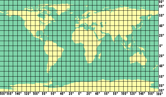
Latitude and longitude lines are drawn on a map like a grid. Latitude lines are
horizontal (they go sideways). Longitude lines are vertical (they go up and
down). We can find or report a location by looking at the point where latitude
and longitude lines intersect. The values of latitude and longitude lines are
called coordinates.
Latitude and longitude are reported in units called degrees. These degrees are related to angles and have nothing to do with temperature. The equator is 0° latitude. It divides the Earth into the northern and southern hemispheres. As we move north of the equator, latitude is reported as degrees north. This reads as L___°N. As we move south of the equator, latitude is reported as degrees south, or L____°S. The greatest latitudes are 90°N (the north pole) and 90°S (the south pole).
The starting point for longitude is the Prime Meridien, which is 0° longitude. Like the equator, this line divides the world into halves, the eastern and the western hemisphere. The longitude lines to the east of the Prime Meridien are reported as degrees east, or Lo___°E. As we move west of the Prime Meridien, longitude is reported as degrees west, or Lo___°W. The greatest line of longitude is 180° .
In order to be more precise in reporting locations, the spaces between latitude and longitude lines are divided into smaller units called minutes. These units have nothing to do with time. There are 60 minutes between each degree of latitude or longitude. Minutes are written as " ' " for short.
Lat & Longitude MAPS
Copyright © Ocean Of Know